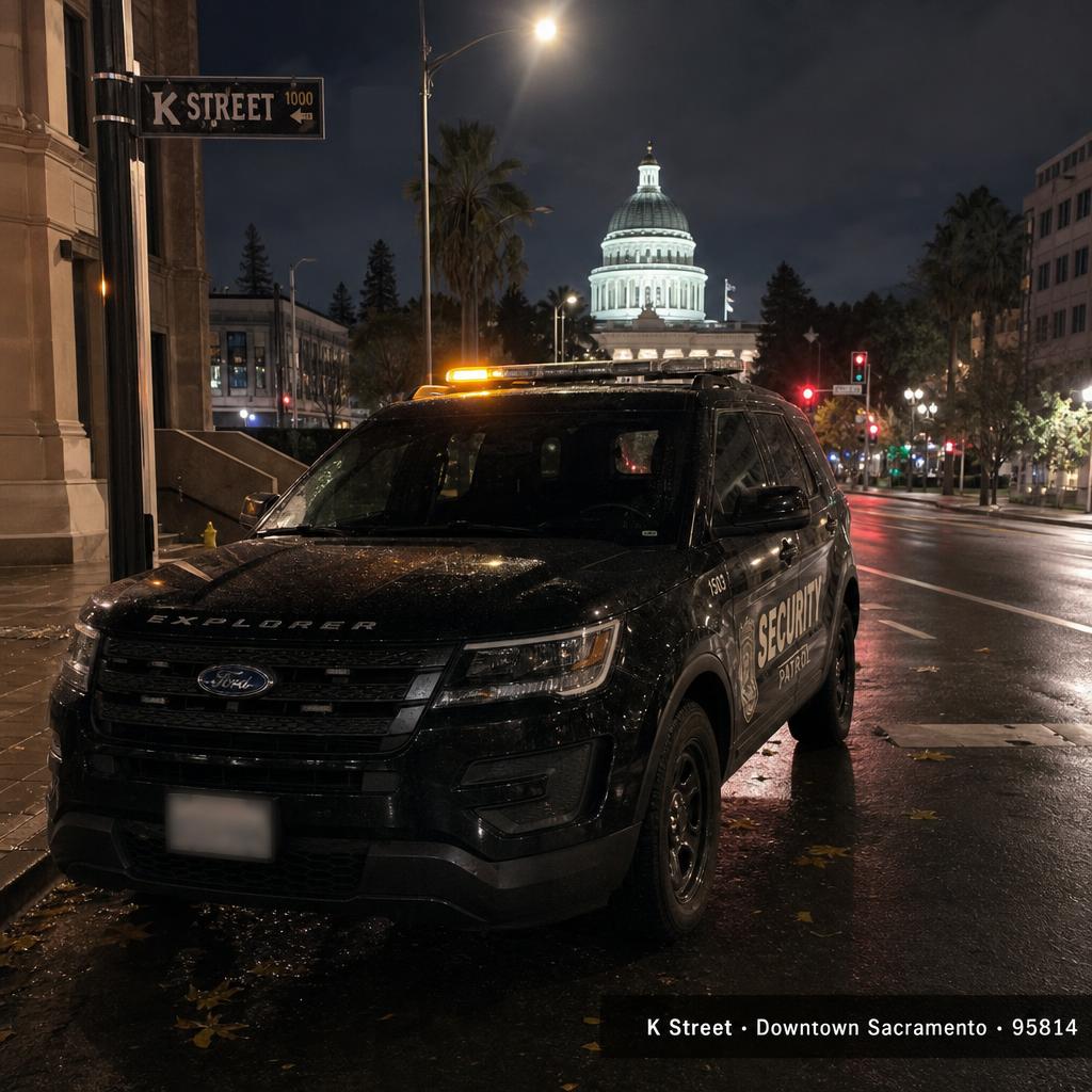
Sacramento ZIP Codes (95814–95864)
Search intent · sacramento zip code · sacramento zip codes · downtown sacramento zip
Overview
Sacramento city ZIP codes run 95811–95838 for the urban core and 95820–95864 for the eastern and southern neighborhoods. 95814 is downtown / Capitol, 95816 is Midtown, 95818 is Land Park, 95819 is East Sacramento, 95820 is Tahoe Park / Oak Park, 95822 is South Land Park / Hollywood Park, 95823 is Meadowview / Valley Hi, 95824 is Lemon Hill / Fruitridge, 95825/95864 are Arden-Arcade / Sierra Oaks, 95828/95829 are Vineyard and Florin, 95831 is Pocket-Greenhaven, 95832 is South Sacramento / Meadowview, 95833/95834/95835 are North and South Natomas, 95838 is Del Paso Heights / Hagginwood.
Safety context (informational)
Property and vehicle crime per Sacramento PD CompStat concentrates in 95820, 95823, 95824, 95828 and 95838. 95819, 95818, 95831 and 95864 consistently track at or below city median. Informational only — every ZIP has good people; visible patrol pays back fastest where calls run hot.
Patrol coverage on this street
Stormhammer covers all 21 Sacramento ZIPs nightly with marked Ford Explorer drive-by, $15 per GPS-stamped tour. Pick your ZIP cluster below — every block routes to a coverage page with the specific apartment, HOA and storefront footprint we already run.
Sacramento ZIP Codes (95814–95864) patrol mini-map
Click a neighbor pin to jump to that city's patrol page.
Service-area map · scroll to load
- What ZIP code is downtown Sacramento?
- Downtown Sacramento is ZIP 95814, anchored by the State Capitol, Golden 1 Center / DOCO, K Street and the Capitol Mall corridor. 95811 covers the western edge near Old Sacramento and the railyards.
- How many ZIP codes does the city of Sacramento have?
- The City of Sacramento has 21 primary ZIP codes (95811 through 95838, plus 95864). Sacramento County contains roughly 60 ZIPs total across all incorporated cities and unincorporated communities.
Sacramento Crime Map
Search intent · sacramento crime map · sacramento crime statistics · sacramento crime rate by zip
Overview
Sacramento PD publishes an interactive crime map at sacpd.org/crime-mapping, refreshed nightly with FBI Part 1 incidents. Sacramento County Sheriff publishes a parallel feed at sacsheriff.com for unincorporated areas (Arden-Arcade, North Highlands, Antelope, Fair Oaks, Orangevale, Carmichael).
Safety context (informational)
Reading a crime map well: filter by Part 1 only, set the radius to a quarter-mile around your address, and look at the rolling 90-day vehicle / burglary / vandalism counts — those are the categories visible patrol moves the needle on. Drive-by patrol with body-worn camera and trespass paperwork on file at SacPD reduces repeat-call addresses in published case studies.
Patrol coverage on this street
Send us your address and we'll pull the 90-day Part 1 footprint, show you the closest patrol route, and quote a $15/visit nightly drive-by program before the call ends.
Sacramento Crime Map patrol mini-map
Click a neighbor pin to jump to that city's patrol page.
Service-area map · scroll to load
- Where can I find a Sacramento crime map?
- Sacramento PD publishes an official crime map at sacpd.org/crime-mapping (nightly refresh, FBI Part 1 incidents). Sacramento County Sheriff publishes the unincorporated-area equivalent at sacsheriff.com.
North Highlands
Search intent · north highlands sacramento · north highlands ca · north highlands crime
Overview
North Highlands is the unincorporated community north of the American River between Watt Ave and Antelope Rd — former McClellan AFB footprint, McClellan Park business district, and the Highlands High / Foothill Farms residential belt.
Safety context (informational)
North Highlands tracks above county median for property crime per Sheriff CompStat, especially along the Watt Ave and Auburn Blvd commercial belt. Residential pockets around Foothill Farms and the McClellan Park edge are quieter.
Patrol coverage on this street
Storefront patrol along Watt Ave / Auburn Blvd, apartment patrol in the Foothill Farms belt, and after-hours patrol at the McClellan Park tenant buildings.
North Highlands patrol mini-map
Click a neighbor pin to jump to that city's patrol page.
Service-area map · scroll to load
- Is North Highlands safe?
- North Highlands has historically tracked above Sacramento County median for property crime, with most incidents concentrated on the Watt Ave and Auburn Blvd commercial corridors. Residential Foothill Farms and the McClellan Park edge are quieter.
Rosemont
Search intent · rosemont sacramento · rosemont ca · rosemont high school
Overview
Rosemont is the unincorporated community east of Sacramento between US-50 and Folsom Blvd, anchored by Rosemont High, Hagan Community Park, and the College / Florin Perkins residential belt north of Mayhew Rd.
Safety context (informational)
Rosemont tracks at or near county median for most crime categories. Property crime concentrates at the Rosemont Plaza and Bradshaw Rd retail anchors.
Patrol coverage on this street
HOA patrol in Rosemont's single-family pockets, storefront patrol at the Rosemont / Bradshaw retail anchors, and after-hours patrol at Hagan Park adjacent properties.
Rosemont patrol mini-map
Click a neighbor pin to jump to that city's patrol page.
Service-area map · scroll to load
- Is Rosemont Sacramento a good neighborhood?
- Rosemont is widely considered one of the quieter East Sacramento area suburbs, tracking near county median for crime and anchored by Rosemont High, Hagan Park and access to US-50.
Florin Road
Search intent · florin road sacramento · florin rd · florin mall
Overview
Florin Rd runs east-west across South Sacramento between Land Park and the Vineyard / Florin ZIPs (95823, 95828, 95829). Anchors include the Florin Towne Centre, Florin / 65th light-rail stop, Florin High and the Stockton Blvd / Florin retail belt.
Safety context (informational)
Florin Rd corridor reports above-median property crime per Sacramento PD CompStat, especially around the Florin Towne Centre / Stockton Blvd intersection and the apartment communities between Power Inn and 65th St.
Patrol coverage on this street
Storefront patrol along Florin Rd, apartment patrol in the 65th St / Power Inn cluster, and after-close lot patrol at Florin Towne Centre adjacent properties.
Florin Road patrol mini-map
Click a neighbor pin to jump to that city's patrol page.
Service-area map · scroll to load
- Is Florin Road Sacramento safe?
- The Florin Rd corridor reports above-median property crime per Sacramento PD CompStat, concentrated around the Florin Towne Centre and the 65th St apartment cluster. Visible patrol pays back quickly on multi-tenant retail along this corridor.
South Sacramento
Search intent · south sacramento · south sac · south sac neighborhoods
Overview
South Sacramento spans Meadowview, Valley Hi, Parkway, Pocket-Greenhaven, Lemon Hill and Florin — a mix of post-war ranch-home neighborhoods, light-industrial along Power Inn, and the Cosumnes River College / Mack Rd retail anchors.
Safety context (informational)
South Sacramento crime exposure varies sharply by sub-pocket. Pocket-Greenhaven tracks well below city median; Meadowview / Valley Hi and Lemon Hill report above median per CompStat.
Patrol coverage on this street
We patrol South Sac apartments along Mack Rd, Florin Rd and Stockton Blvd, plus HOA tours in Pocket-Greenhaven and storefront sweeps at the Cosumnes River College retail belt.
South Sacramento patrol mini-map
Click a neighbor pin to jump to that city's patrol page.
Service-area map · scroll to load
- What is considered South Sacramento?
- South Sacramento generally covers everything south of Broadway / Highway 99 to the Elk Grove boundary — including Land Park, Pocket-Greenhaven, Meadowview, Valley Hi, Parkway, Lemon Hill and Florin.
Fair Oaks
Search intent · fair oaks ca · fair oaks village · fair oaks bridge
Overview
Fair Oaks is the unincorporated community east of Carmichael along the American River — Fair Oaks Village, Fair Oaks Park, the Fair Oaks Bridge over the American River bike trail, and the Madison / Sunrise residential belt.
Safety context (informational)
Fair Oaks tracks among the quieter Sacramento County communities per Sheriff CompStat, comparable to Carmichael and Orangevale. Property crime exposure concentrates at Madison Ave / Sunrise Blvd retail intersections.
Patrol coverage on this street
HOA patrol in the Fair Oaks Village / Bridge Street pocket, storefront patrol on Madison and Sunrise, and after-close lot patrol at the Bel Air anchor center.
Fair Oaks patrol mini-map
Click a neighbor pin to jump to that city's patrol page.
Service-area map · scroll to load
- Is Fair Oaks CA a good place to live?
- Fair Oaks consistently ranks among the quieter Sacramento County communities, with tree-lined neighborhoods near the American River bike trail, the historic Fair Oaks Village shopping district, and strong access to Sunrise Blvd / Folsom employment.
Carmichael
Search intent · carmichael ca · carmichael park · carmichael sacramento
Overview
Carmichael is the unincorporated community between Arden-Arcade and Fair Oaks — anchored by Carmichael Park, Ancil Hoffman Park on the American River, Mission / Marconi Ave retail and the Jesuit / Del Campo school belt.
Safety context (informational)
Carmichael tracks at or below county median for most crime categories per Sheriff CompStat. Property crime concentrates on Fair Oaks Blvd and Marconi Ave commercial intersections.
Patrol coverage on this street
HOA patrol in Carmichael's single-family pockets, storefront patrol on Fair Oaks Blvd and Marconi, and after-hours patrol at Ancil Hoffman Park adjacent properties.
Carmichael patrol mini-map
Click a neighbor pin to jump to that city's patrol page.
Service-area map · scroll to load
- Is Carmichael CA safe?
- Carmichael tracks at or below Sacramento County median for most crime categories. The community has strong school options (Jesuit, Del Campo) and the American River parkway running along its southern edge.
Orangevale
Search intent · orangevale ca · orangevale sacramento · orangevale community center
Overview
Orangevale is the unincorporated community north of Folsom Lake — Orangevale Community Park, Casa Roble High, and the Greenback / Hazel residential belt with Folsom Lake College nearby.
Safety context (informational)
Orangevale tracks among the quieter Sacramento County communities per Sheriff CompStat. Property crime exposure is concentrated at Greenback Ln and Hazel Ave commercial intersections.
Patrol coverage on this street
HOA patrol across Orangevale's single-family pockets, storefront patrol on Greenback and Hazel, and after-close patrol at the Folsom Lake College adjacent retail belt.
Orangevale patrol mini-map
Click a neighbor pin to jump to that city's patrol page.
Service-area map · scroll to load
- Is Orangevale CA a good place to live?
- Orangevale is considered one of the quieter east-county Sacramento communities, with single-family neighborhoods, Folsom Lake recreation access, and strong school options through the San Juan Unified district.
Antelope
Search intent · antelope ca · antelope sacramento · antelope crime
Overview
Antelope is the unincorporated community north of Sacramento between North Highlands and Roseville — anchored by Antelope Rd, Antelope High, and the master-plan neighborhoods built out in the 1990s/2000s along Walerga and Don Julio.
Safety context (informational)
Antelope tracks near county median per Sheriff CompStat. Property crime exposure concentrates at the Antelope Rd retail intersections (Walerga, Roseville Rd).
Patrol coverage on this street
HOA patrol across Antelope's master-plan tracts, storefront patrol on Antelope Rd, and after-close patrol at the Antelope Crossing retail belt.
Antelope patrol mini-map
Click a neighbor pin to jump to that city's patrol page.
Service-area map · scroll to load
- Is Antelope CA safe?
- Antelope tracks near Sacramento County median for crime per Sheriff CompStat. It's a popular bedroom community for Roseville and Sacramento employment, with master-plan neighborhoods built largely in the 1990s and 2000s.
Vineyard / Florin
Search intent · vineyard sacramento · vineyard ca · vineyard florin
Overview
Vineyard is the unincorporated South Sacramento community between Elk Grove and the city of Sacramento — anchored by Bradshaw Rd, Calvine Rd and the Vineyard / Florin residential belt.
Safety context (informational)
Vineyard tracks above county median for property crime per Sheriff CompStat, especially around the Calvine Rd / Bradshaw retail intersections.
Patrol coverage on this street
HOA patrol across Vineyard's single-family pockets, storefront patrol on Bradshaw and Calvine, and apartment patrol in the Bradshaw / Florin Perkins multi-family cluster.
Vineyard / Florin patrol mini-map
Click a neighbor pin to jump to that city's patrol page.
Service-area map · scroll to load
- Where is Vineyard Sacramento?
- Vineyard is the unincorporated South Sacramento community between Elk Grove and the City of Sacramento, anchored by Bradshaw Rd and Calvine Rd in ZIP 95829.
West Sacramento
Search intent · west sacramento safe · west sacramento · west sac neighborhoods
Overview
West Sacramento sits across the Tower Bridge in Yolo County — anchored by the Sutter Health Park River Cats stadium, Bridge District riverfront, Southport master-plan community, and the industrial / port footprint along the Sacramento Deep Water Ship Channel.
Safety context (informational)
West Sacramento has invested heavily in PD staffing and Bridge District redevelopment. Southport and the Bridge District track at or below county median for most crime categories; older Broderick / Bryte pockets along West Capitol Ave report higher property crime.
Patrol coverage on this street
Stormhammer covers West Sac apartments in Southport, storefront patrol on West Capitol Ave and Jefferson Blvd, and warehouse patrol along Industrial Blvd and the port footprint.
West Sacramento patrol mini-map
Click a neighbor pin to jump to that city's patrol page.
Service-area map · scroll to load
- Is West Sacramento safe?
- Newer West Sacramento neighborhoods (Southport, Bridge District) track at or below Yolo County median for crime. Older Broderick / Bryte pockets along West Capitol Ave report higher property crime per West Sac PD data.
Elk Grove Crime Rate
Search intent · elk grove ca crime rate · is elk grove safe · elk grove crime
Overview
Elk Grove consistently ranks among the safer larger cities in California per FBI UCR data — Elk Grove PD reports the city's violent crime rate is well below state and national averages, and property crime concentrates at the Elk Grove Auto Mall, Promenade outlets and the Laguna Blvd / Bruceville retail belt.
Safety context (informational)
Per the latest FBI UCR + Elk Grove PD CompStat, Elk Grove's violent crime rate sits well below California state median for cities over 150,000 population. Property crime tracks slightly below state median, concentrated at retail anchors and the Auto Mall.
Patrol coverage on this street
Elk Grove patrol covers Laguna West, Anatolia, Stone Lake, East Franklin and the Auto Mall / Promenade retail belt with nightly drive-by, breezeway walks and lock-ups.
Elk Grove Crime Rate patrol mini-map
Click a neighbor pin to jump to that city's patrol page.
Service-area map · scroll to load
- What is Elk Grove's crime rate?
- Elk Grove's violent crime rate sits well below California state median for cities over 150,000 population per FBI UCR data, and the city is consistently ranked among the safer larger cities in California. Property crime mirrors retail traffic at the Auto Mall and Promenade outlets.
Rancho Cordova Crime Rate
Search intent · rancho cordova crime rate · rancho cordova crime · is rancho cordova dangerous
Overview
Rancho Cordova crime rate per Rancho Cordova PD + FBI UCR data tracks near California state median for cities of similar size. East-side master-plan communities (Anatolia, Sunridge, Stonecreek) report well below state median for both violent and property crime.
Safety context (informational)
Rancho Cordova invested heavily in PD staffing post-incorporation. Crime exposure concentrates on the older West Rancho apartment blocks along Folsom Blvd and Mills Station; East Rancho master-plan tracts track at or below county median.
Patrol coverage on this street
Anatolia, Sunridge, Stonecreek and the Folsom Blvd / Mills Station apartment belt all get nightly drive-by, breezeway walks and lock-ups. $15 per GPS-stamped tour.
Rancho Cordova Crime Rate patrol mini-map
Click a neighbor pin to jump to that city's patrol page.
Service-area map · scroll to load
- What is Rancho Cordova's crime rate?
- Rancho Cordova's overall crime rate per FBI UCR tracks near California state median for cities of similar size. East-side master-plan communities (Anatolia, Sunridge, Stonecreek) report well below state median; older West Rancho apartment blocks report higher property crime.
Citrus Heights Crime
Search intent · citrus heights crime · is citrus heights safe · citrus heights crime rate
Overview
Citrus Heights crime per Citrus Heights PD + FBI UCR tracks near California state median for cities of similar size. Sunrise Mall area and Auburn Blvd report above-median property crime; Sungarden, Sylvan and Stock Ranch residential pockets track below median.
Safety context (informational)
Property crime exposure concentrates at the Sunrise Mall corridor and along Auburn Blvd. Residential master-plan neighborhoods track at or below county median.
Patrol coverage on this street
Sunrise Mall adjacent retail patrol, Auburn Blvd storefront sweeps, and HOA patrol across the Stock Ranch / Sungarden / Sylvan residential pockets.
Citrus Heights Crime patrol mini-map
Click a neighbor pin to jump to that city's patrol page.
Service-area map · scroll to load
- Is Citrus Heights safe?
- Citrus Heights crime per FBI UCR tracks near California state median for cities of similar size. The Sunrise Mall corridor and Auburn Blvd report above-median property crime; residential Stock Ranch, Sungarden and Sylvan pockets track at or below median.